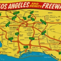
Cartoon map of Los Angeles and Vicinity Freeways.
Title
Cartoon map of Los Angeles and Vicinity Freeways.
Description
Cartoon map of Los Angeles and Vicinity Freeways.
Date
c1960s
Language
English
Identifier
VR/PC/AV/31
Original Format
Postcard
Physical Dimensions
5” x 3.5” (14 cm x 9 cm)
Collection
Citation
“Cartoon map of Los Angeles and Vicinity Freeways.,” Valley Relics Museum - Archives, accessed January 25, 2026, https://valleyrelicsmuseum.org/archives/items/show/115.

